

AceWeatherDesk – Snow and ice are set to hit parts of the UK in a series of wintry showers.

Ace Press News From Cutting Room Floor: Published: Nov.29: 2023: U.K MET Office News& BBC Weather & BBC News By Simon King & George Wright: TELEGRAM Ace Daily News Link https://t.me/+PuI36tlDsM7GpOJe
Cold conditions sweep across UK
Much colder conditions are expected to affect the UK for the rest of this week and into the weekend, with daytime temperatures rooted in single figures and overnight temperatures falling well below freezing in many places.
With the UK sitting in cold air from Scandinavia the weather is turning much colder for the rest of this week and the start of next with daytime temperatures struggling to get above single figures and overnight temperatures staying below freezing for much of the country.
⚠️ Yellow weather warning issued ⚠️
Snow and ice across parts of southwest England
Thursday 0300 – 1600
Latest info 👉 https://t.co/QwDLMfRBfs
Stay #WeatherAware⚠️ pic.twitter.com/rYWgghIPyW— Met Office (@metoffice) November 29, 2023
Met Office Chief Meteorologist, Neil Armstrong, said:
“ We’ve already seen snow settling in parts of eastern Scotland and northeastern England. As the cold air continues to spread across the UK we also expect to see some snow over the high ground of southwest England overnight tonight and through tomorrow.
“Snow showers will continue along the North Sea coast with a northeasterly air flow, leading to further accumulations over higher ground. Where the showers fall as rain there is a risk of icy patches forming overnight with temperatures widely dipping below freezing. A number of National Severe Weather Warnings have been issued and these are likely to be updated through the week so stay up to date with the forecast for your area.”
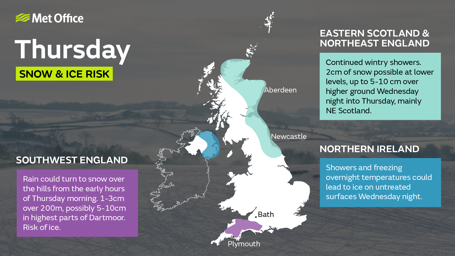
Snow has been settling in northeastern parts of the UK, with 5cm overnight at Fylingdales in the North York Moors, 2cm at Aviemore and 1 cm at Albemarle and Bingley.
Remaining cold next week
The cold regime looks likely to continue into next week, with a good deal of dry sunny weather for many. However, showers remain possible, particularly in eastern coastal areas, and these could be wintry at times.
The UKHSA has issued yellow and amber cold-health alerts for the health sector covering northern regions of England through until the 5th December.
Prepare for the cold
RAC Breakdown spokesman Rod Dennis said: “We expect to see a sharp rise in breakdowns this week as cold weather is the nemesis of older car batteries. It exposes any weaknesses in battery health and leads to a huge jump in the number of cars that won’t start.
“We urge every driver who has noticed their car is sluggish to start to get it checked by a reputable mobile mechanic or garage as soon as possible. Anyone who doesn’t, risks their car letting them down just at the very moment they need it, whether they’re heading to work or on the way to an important appointment.
“We also strongly recommend drivers pack some winter gear should their cars let them down and they find themselves stuck in sub-zero temperatures. Extra warm clothes, food and drink, plus a fully charged phone powerbank are all a must.”
Snowfall in late autumn or early winter doesn’t generally linger because ground temperatures broadly remain relatively high, especially compared with values in late winter, after the ground loses more of its warmth.
The Met Office says people should get ready for potentially “hazardous conditions” from 17:00 GMT on Tuesday overnight into Wednesday morning.
Affected regions are northern and eastern Scotland, Shetland and Orkney, north east England and East Yorkshire.
London and areas of south east England could see some snow flurries later this week, forecasters say.
The latest forecast for the region indicates snow showers are more likely on Friday, but there could be flurries on Thursday.
There will be freezing weather on Tuesday night for many people across the country with temperatures down to -2C (28.4F) to -6C degrees.
Snow is expected to accumulate over the higher ground of eastern Scotland and north east England.
With wintry showers and temperatures below zero, icy stretches may form on untreated surfaces into Wednesday morning, the Met Office said.
There is also the chance of one to three centimetres of snow accumulating to relatively low levels and up to five centimetres over the higher ground of north east Scotland.
Yellow warnings for snow and ice will remain in place in areas of Scotland and north east England until Thursday and the difficulties in forecasting snow
Temperatures dropped below freezing for much of the country over the weekend. The coldest recorded temperature so far this autumn was -7.7C in Shap, Cumbria, on Saturday morning.
The cold air is coming from Scandinavia where people there are experiencing near-record cold November weather. Wintry showers are forming in the North Sea and will come onshore across eastern parts of the UK.
The cold weather is expected to to stick around into next week.
Maximum temperatures this week will be around 2C to 6C but it may not even get above freezing in parts of Scotland and northern England.
While snow may fall in London and south east England later this week, it is not likely to settle or cause disruption.
Snowfall at this time of year does not generally linger because ground temperatures are relatively high, especially compared with late winter, the Met Office says.
The UK Health Security Agency has issued an amber cold-health alert for the health sector for northern regions of England, meaning “significant impacts are probable”.
The amber alert indicates that impacts of the cold weather are likely to be felt across the whole health service, with the potential for the whole population to be at risk, the agency says.
A less severe yellow cold-health warning is in place for the Midlands. Both alerts are in force from 18:00 GMT on Tuesday, running until 5 December.
Wales to get colder with chance of snow
Can I get a Cold Weather Payment?
Editor says …Sterling Publishing & Media Service Agency is not responsible for the content of external site or from any reports, posts or links and thanks for following as always appreciate every like, reblog or retweet and comment thank you
@acenewsservices

You must be logged in to post a comment.